There has been significant press coverage of the King Tides experienced around New Zealand last weekend.
Localised surface flooding of low-lying roads in the Auckland region, particularly the Northwestern motorway and Tamaki Drive have been reported with peak tides up to 0.7m above normal. These King tides are produced when a normal monthly Spring tide (at new and full moon) coincides with the closest approach of the moon to earth. The additional gravitational pull on the oceans associated with the coincidence of these events produces both the highest and lowest tides in a year. The peak tide can be intensified by the weather conditions, but in this case most of the country lay under a high pressure ridge that was associated with calm, sunny weather.
As part of an awareness campaign sponsored by Auckland Council, the public were encouraged to photograph King tides around the region and submit them to create a living record of the changes to our coasts and shorelines and a glimpse of what our daily tides may look like in the future as a result of sea level rise. Sea level measured in Auckland Harbour has been rising at a rate of 1.6mm a year over the past century and we are warned to plan for an increase of up to a metre by 2100. This increase is associated with the world-wide melting of glaciers that adds water to the oceans and thermal expansions of the seas as the planet warms. The rise will continue for centuries regardless of any global strategy to combat greenhouse gas emissions.
Under scenarios envisaged by NIWA, the high tides observed around Auckland this weekend will be normal by 2060 and it doesn’t take much imagination to contemplate the impact of future King tides that are up to 0.7m above those experienced this weekend. Adaptation to this reality is staring to filter into planning decisions – regardless of what Bill English and Gerry Brownlee might think about climate change. The New Zealand Transport Agency is about to commence a two-year project to raise the height of the causeway on the Northwestern motorway by 1.5m, and other infrastructure projects must surely be under consideration around the country.
Auckland Council is also starting to pay more than lip service to the concept of climate change. Although the recently adopted Hauraki Gulf Islands District Plan (HGIDP) only contains a single reference to this subject, the newly proposed Auckland Unitary Plan has significantly improved the portrayal of this issue. Planning maps now define areas at risk from inundation i.e. less than 3m above MHWS and now much of the coastal land around Auckland (except on Gulf islands) is included within Natural Hazard zones. New rules associated with these areas will require all development applications be accompanied by a report by a suitably qualified engineer that confirms that the land on which the activity is located is not subject to the following: a. coastal erosion or inundation over a 100 year timeframe. This strategy follows other local bodies around the country that recognise the risk to coastal communities and explicitly warn of potential impacts associated with climate change. After all it would be inappropriate for Councils not to warn of a clear and present danger that could give rise liability at a later date.
The only problem with this planning approach is that adoption of the new Unitary Plan is still several years in the future as the hearings and appeal process will surely significantly delay ratification. Clearly the 10 year cycle of District Plans is too slow and cumbersome to react to risk. Climate change was not on the then Auckland City Council radar when the HGIDP was drafted in 2006, so when the Plan was finally adopted nearly seven years later in 2013, it is in many respects already outdated. It will be another 10 years before the Gulf islands are finally incorporated into the Unitary Plan with its recognition and protections associated with development in at risk coastal zones. The current situation on Waiheke Island sees Resource Consent applications for residential development within the so-called Coastal Protection Yard, where planners and engineers give no consideration to hazards associated with sea level rise and argue they do not have the tools to do so.
While the Resource Management Act clearly states consideration must be given to the effects of climate change in Resource Consent matters, there seems to be a reluctance to integrate this with a Plan that does not address the matter.
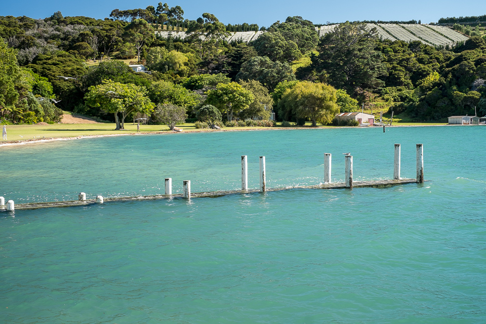 King tide at Orapiu Beach, Waiheke Island: 9:57am on 2nd February 2014. The grassed area currently has a Resource Consent application under consideration for the construction of two houses and sea level rise is not a consideration in this application. Note person on lawn for scale.
